Blog

  • From Mapping to Geospatial: The Evolution of Australia’s Professional Associations

    Dean Howell

    This article was originally published in Linkedin

    Australia’s geospatial community has always been shaped by collaboration, innovation, and a drive to stay relevant as technology advances. The recent receivership of the Geospatial Council of Australia (GCA) has left a significant gap, both symbolically and practically, as Australia no longer has a unified professional or industry association for the mapping, GIS, and spatial sciences sector.

    To understand how we reached this point, it’s important to look back at the associations that shaped the sector, and the path of mergers and transitions that ultimately created GCA.


    The Early Foundations: Surveying & Mapping Bodies

    The origins of Australia’s professional representation in the geospatial sector lie in surveying and cartography.

    • The Institution of Surveyors Australia (ISA) was one of the earliest national professional bodies, representing surveyors across disciplines and states. Its focus was on education, professional standards, and recognition of surveying as a regulated discipline.
    • Cartographers established their own national body in 1952, the Australian Institute of Cartographers (AIC), representing the craft and science of mapmaking. It changed its name to the Mapping Sciences Institute, Australia (MSIA) in 1995.

    These organisations reflected the traditional backbone of spatial sciences: surveying for accuracy and land management, and cartography for the representation and communication of spatial information.


    Expanding Horizons: GIS, Remote Sensing & Urban Information Systems

    From the 1970s onwards, Geographic Information Systems (GIS) and Remote Sensing began to reshape how Australians worked with spatial data. As new technologies emerged, new specialist organisations followed:

    • Mapping Sciences Institute, Australia (MSIA) grew from the cartographic community, broadening into GIS, photogrammetry, and spatial data management.
    • The Remote Sensing and Photogrammetry Association of Australasia (RSPAA) catered to academics and practitioners using imagery and aerial survey methods.
    • The Australian Urban and Regional Information Systems Association (AURISA) was the local arm of URISA (Urban and Regional Information Systems Association), which had been founded in North America. AURISA gave GIS and spatial information professionals a voice in Australia and New Zealand at a time when digital mapping was in its infancy.

    This period saw the industry diversifying rapidly – from traditional surveying into the wider spatial sciences.


    The First Consolidations: From URISA and ISA to SSI

    By the early 2000s, the sector faced fragmentation across multiple overlapping associations. The first big move towards unification came in 2003, when:

    • The Institution of Surveyors Australia (ISA),
    • AURISA (the Australian Urban and Regional Information Systems Association, linked to URISA), and
    • The Remote Sensing and Photogrammetry Association of Australasia (RSPAA)

    all reconstituted themselves into the Spatial Sciences Institute (SSI).

    The new SSI represented a landmark moment: for the first time, surveyors, GIS professionals, photogrammetrists, and remote sensing specialists were housed in one professional organisation.


    From SSI to SSSI

    While SSI created a broader professional body, tensions remained around governance and representation. Some state divisions of ISA (such as in Victoria) were uncomfortable with the transition, and re-established independent entities like the Institution of Surveyors Victoria (ISV) in 2007.

    Nevertheless, in 2009, SSI formally merged with the remaining Institution of Surveyors Australia to form the Surveying & Spatial Sciences Institute (SSSI).

    This was a watershed:

    • Surveying (a regulated profession) and the broader spatial sciences (GIS, remote sensing, cartography, etc.) were united nationally.
    • SSSI became the peak body for individual professionals in Australia’s geospatial sector, providing certification, professional development, and representation.

    Industry Representation: The Role of SIBA

    While SSSI focused on individuals and professional standards, the business side of the industry needed its own voice. That role was played by the Spatial Information Business Association (SIBA), which represented companies, consultancies, and vendors.

    SIBA advocated for industry growth, government partnerships, and the economic importance of geospatial solutions. Later, SIBA partnered with the Geospatial Information & Technology Association (GITA ANZ), strengthening its role as a commercial and business voice.

    By the 2010s, the landscape had stabilised into two clear entities:

    • SSSI – representing professionals.
    • SIBA|GITA – representing businesses and industry.

    The Birth of the Geospatial Council of Australia

    By the late 2010s, there was widespread recognition that two separate associations still left the sector fragmented. After years of discussions, SSSI and SIBA|GITA merged in 2022 to form the Geospatial Council of Australia (GCA).

    The GCA was ambitious in scope:

    • A single body for professionals and businesses.
    • A unified voice for advocacy to government.
    • A hub for professional development, training, networking, and certification.

    It was designed to be the “one stop shop” for geospatial representation in Australia.
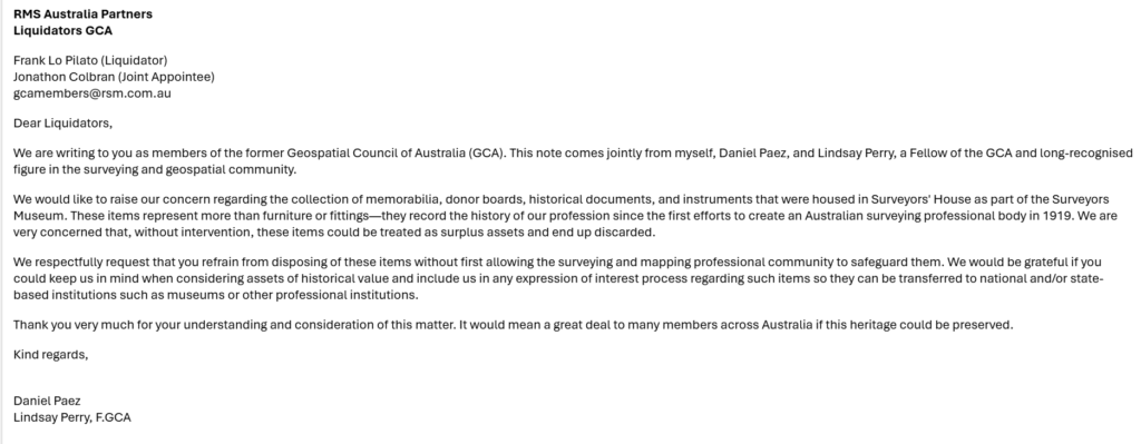

    A Sudden Void

    But in mid-2025, GCA went into receivership. For the first time in more than 50 years, Australia has no national professional or industry association representing the geospatial sector.

    The implications are significant:

    • Professionals lose a body for recognition, certification, and networking.
    • Businesses lose an industry advocate.
    • Government loses a clear contact point for geospatial policy and workforce development.

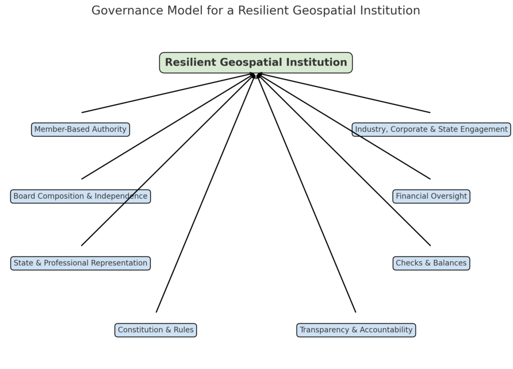
    Conclusion: Lessons from the Journey

    From ISA and AIC, through AURISA and URISA links, to SSI and finally SSSI, Australia’s professional associations reflected the expanding scope of geospatial practice. Each merger aimed to reduce fragmentation and unify the community.

    The creation of GCA in 2022 was the culmination of this decades-long process. Its receivership in 2025 is therefore more than just an administrative failure – it represents the collapse of a vision to bring every part of the sector together.

    The story of our associations is one of adaptation. If history tells us anything, it’s that the next chapter will not be a simple rebuild of the past – it will need to be something new, more relevant, and more resilient.

  • Designing Governance for a Resilient profesional Institution

    By Peta Riles (Corporate governance and administration)

    The collapse of the Geospatial Council of Australia highlighted a critical lesson for the profession: strong governance and financial oversight are essential, but they are not enough on their own. A sustainable institution must also be built on broad engagement that gives legitimacy and resilience. A future body should be member-driven at its core, while also establishing formal mechanisms that bring in perspectives from industry, corporate partners, and state associations.

    At the heart of such an institution are its members. Individual professionals form the core, and their authority should extend to strategic and extraordinary decisions made through annual or special general meetings. This includes board elections, constitutional amendments, budgets, and major policy directions. Structured advisory councils and committees should feed into the board, ensuring that proposals reflect the breadth of the profession before being put to the membership for approval.

    Industry, corporate, and state-based associations also play a vital role. Their expertise, sectoral knowledge, and ability to identify risks enrich decision-making. By participating in advisory councils, project committees, and consultation mechanisms, they contribute meaningfully without undermining the legitimacy of a member-led system. The balance lies in ensuring they have influence but not voting rights.

    The board itself must embody both independence and expertise. A structure of seven to nine directors, including two to three independent directors with strong backgrounds in finance and governance, would strengthen oversight. The board’s role should be distinct from operational management, focusing on strategy, fiduciary responsibility, and risk. A dedicated treasurer or finance director should monitor budgets, report transparently, and chair the audit and risk committee. Regular financial updates to members would enhance accountability and ensure that risks are identified early, a safeguard made urgent by the lessons of the GCA collapse.

    Representation at both the state and professional levels is also essential. State committees would preserve local and regulatory connections, while specialist advisory councils—for surveying, GIS, remote sensing, and other areas—would provide structured guidance without overloading the board. Term limits for directors encourage renewal and prevent entrenchment, while conflict-of-interest registers and annual disclosures guard against misuse of authority. Independent audit and risk committee reports should go directly to the board and be made accessible to members through annual reports.

    A clear and transparent constitution underpins the whole system. It should codify membership criteria, board structure, officer roles, election processes, meeting requirements, and dispute resolution procedures. By clearly demarcating member authority from advisory input, the constitution ensures continuity and stability. Transparency is further reinforced by the annual publication of audited financial statements, governance and risk statements, and records of board decisions. Regular member forums would keep dialogue open and maintain alignment with the profession’s needs.

    By combining member-led voting, structured stakeholder engagement, independent expertise, and robust financial oversight—underpinned by a clear constitution—this model offers simplicity, resilience, and inclusivity. It balances legitimacy with accountability and ensures that the institution remains responsive to the wider geospatial sector. In doing so, it lays the groundwork for a professional body that can endure and provide lasting value for its members and the broader community.

  • From Surveyors Australia

    Surveyors Australia has released a message at an important moment of transition for our profession. In his update, President Craig Turner outlined the organisation’s strength, purpose, and vision for the future.

    The message highlights that Surveyors Australia exists solely to represent and advance surveyors at the national level, with formal agreements in place with every state surveying body and active international engagement through FIG. Over the past year, key outcomes have included new education pathways, national salary and hourly rate surveys, and the rollout of certification for Engineering Surveyors.

    Looking ahead, Surveyors Australia has set clear priorities: expanding education access, modernising workforce classifications, strengthening certification, and engaging with new technologies such as AI, while keeping human expertise at the core of the profession.

    This is a timely and encouraging message that provides stability and clarity for surveyors across Australia.

    How do you see the future of national representation for surveyors evolving?
    What priorities should the profession focus on most in the year ahead?
    In what ways can Surveyors Australia best support its members in a changing environment?

    Below the full communication by Surveyors Australia

  • Memorabilia – the need to preserve history

    We have been working to save the surveying and mapping memorabilia held at the Surveyors’ House during the administration of the Geospatial Council of Australia.

    Together with colleagues, we reached out to the liquidator to ask that these important items — which reflect the history and achievements of our profession — are not simply discarded. They are part of our shared story and deserve to be preserved for future generations of surveyors and mappers.

    This is an ongoing effort, and we welcome ideas or support from anyone who can help ensure these materials are protected and given a proper home.

    Here is an email we sent to the liquidator to hope the memorabilia might be preserve by the state bodies and other national institutions.

  • What Surveyors and Mappers Can Learn from the Legal Profession in Australia

    The legal profession in Australia provides a clear example of how a profession can balance state responsibilities with national coordination.

    At the state level, every practising lawyer must hold a practising certificate issued by the local admitting authority. For example, in Victoria this is governed under the Legal Profession Uniform Law (Victoria) and administered through the Law Institute of Victoria. Equivalent provisions exist in every state and territory. These state-based regimes ensure professional competence, discipline, and statutory obligations are tied directly to the jurisdictions where lawyers practice.

    At the national level, the profession speaks with one voice through the Law Council of Australia. The Law Council represents Australian lawyers on issues that cross state borders or sit at the federal level. Its remit spans:

    • Areas of law shaped by federal legislation, such as family law, corporations law, migration law and constitutional issues.
    • Policy debates affecting the profession, including access to justice, regulatory harmonisation, diversity and inclusion, and international engagement.

    This dual structure — state statutory licensing and national advocacy — ensures lawyers are regulated where they work, while still having a coordinated voice on matters that affect the profession as a whole.

    For surveyors, mappers and geospatial professionals, the lesson is similar. State-level associations will always be critical, because statutory responsibilities such as land titling and professional licensing remain with the states. But a national body is also essential to manage migration assessments, nationally recognised professions such as hydrographic surveying, federal policy, and Australia’s role in international forums and standards.

    The legal profession shows it is possible to respect state authority while ensuring a strong, united national voice.

    Daniel Paez